


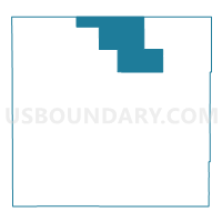
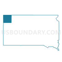
VTD- precinct Ludlow, Harding County, South Dakota
About
Outline

Summary
| Unique Area Identifier | 667361 |
| Name | VTD- precinct Ludlow |
| County | Harding County |
| State | South Dakota |
| Area (square miles) | 191.26 |
| Land Area (square miles) | 191.08 |
| Water Area (square miles) | 0.19 |
| % of Land Area | 99.90 |
| % of Water Area | 0.10 |
| Latitude of the Internal Point | 45.83648000 |
| Longtitude of the Internal Point | -103.42995000 |
Maps

Graphs
Select a template below for downloading or customizing gragh for VTD- precinct Ludlow, Harding County, South Dakota


Neighbors
Neighoring Voting District (by Name) Neighboring Voting District on the Map
- Bowman 39-02 Voting District, Bowman County, ND
- Bowman 39-03 Voting District, Bowman County, ND
- VTD-precinct Fillmore, Harding County, SD
- VTD-precinct Hilton, Harding County, SD
- VTD-precinct Ladner, Harding County, SD
- VTD-precinct Vessel, Harding County, SD
Top 10 Neighboring County Subdivision (by Population) Neighboring County Subdivision on the Map
- North Harding UT, Harding County, SD (548)
- Minnehaha township, Bowman County, ND (24)
- Langberg township, Bowman County, ND (16)
- Ladd township, Bowman County, ND (15)
- Grand River township, Bowman County, ND (12)